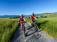
They get bigger and bigger. With every kilometer the view of the mountains of the Estergebirge and especially the view of the high Wetterstein massif with the Zugspitze becomes more impressive. This is what makes up the first part of the tour through the Murnauer Moos for cyclists. You can't get enough of the impressions that the nearby peaks give you.
Good to know
Directions
Once you have started at the Murnau Culture and Conference Center (KTM), drive down the moat according to the signs, turn sharply into Schlossergasserl after about 200 meters, and then head south from Murnauer Untermarkt on the left side of Bundesstraße 2 to get on a bike path. After a gas station, this takes the cyclist left to the Loisach. There you go on a well-paved dirt road towards Eschenlohe, where you are always captivated by the views of the mountains and the Murnauer Moos in front of it. After ten kilometers you come to Eschenlohe, continue into the village and turn right behind the beer garden of the "Alten Wirt", under a railway underpass, and shortly afterwards turn right again to the feeder road to the Murnauer Moos nature reserve.
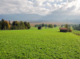
After you have passed the first few hundred meters on the less attractive motorway feeder road, you can hardly notice any traffic anymore. We now walk comfortably on a small tar road towards Grafenaschau. On the left, at the foothills of the Ammergau Alps with the peaks of the Ettaler Manndl, the Aufacker and the Hörnle, you can admire the old farms and hermitages of the community of Schwaigen, nestled tightly into the slope. On the right-hand side, cyclists have wonderful views of the swampy meadows of the Moos and the first Kochel, the small moss mountains on which a unique flora and fauna has been preserved.
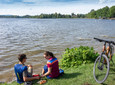
At kilometer 15 you can take a short detour into the moss on an initially tarred path to get a closer look at this fragile habitat. After about a kilometer, the detour leads to a large lake that has only formed over the past ten years, namely only after the mining of gravel on the so-called "Langer Kochenel" was stopped (swimming is prohibited). Back on the road we continue to the small town of Grafenaschau, which has its Café Habersetzer, which is known for a good snack and homemade cakes. The cafe is usually open from Wednesday to Sunday. After another kilometer, turn right at the bridge into Murnauer Moos and then follow the windings of the Lindenbach and later the Ramsach back to Murnau for the next ten kilometers.
Since pedestrians have the right of way in this area, consideration is requested. On this last section of the route there are always beautiful resting and viewing areas. Here you should take your time to enjoy the unique flora and, with a bit of luck, the animal world of the largest intact moor area in Central Europe. Once you have reached the Ramsachkircherl, the "Ähndl", you continue to the right past the Alpenhof Murnau, to the left into Mühlstraße and along the park path back to the starting point at the culture and conference center.
safety instructions
Please always take Considerate pedestrians and hikers. Make yourself noticeable in time, reduce speed and get off on narrow paths and push the bike. We appeal for respectful interaction between hikers and cyclists.
In an emergency, please contact the nearest rescue control center. Regardless of your location, you can reach them anywhere in Germany by calling 112.
The hiking and cycling paths we describe are primarily used for forest management; you use them at your own risk (Section 14 Para. 1 BForestG).
Facilities
To guarantee a smooth bike tour, we recommend the following equipment:
- Bicycle helmet
- Gloves
- Short or long cycling shorts
- Short or long jersey
- rain jacket
- Good shoes, possibly with a click
- sunglasses
- Hydration
- Meals
- First aid kit
- GPS device + second set of batteries
- Current map (scale 1:50)
- Replacement hose, pump
- Tools
- camera
- Money
Arrival & Parking
Public transportation
Bus stop: Murnau post office
Bus routes in and through Murnau:
9601 Weilheim - Huglfing - Uffing - Murnau
9607 Murnau - Ohlstadt - Ettal and back (Note: only open on Saturdays on school days at the Ettal monastery school!)
9611 Kochel - Schlehdorf - Großweil - Ohlstadt - Murnau (Note: The Glentleiten open-air museum is only served from April to October!)
9620 Murnau - Riegsee - Aidling - Murnau
9621 Murnau - Seehausen - Grafenaschau
9631 Murnau - Obersöchering / Uffing - Eglfing
9641 Murnau - Seehausen - Uffing - Kirnberg
Train stop: Murnau train station and Murnau Ort (Murnau - Oberammergau route)
Murnau train station (Munich - Murnau - Garmisch-Partenkirchen route)
Guests in the "Blue Land" region and the "Ammergau Alps" region can use a variety of bus lines and train lines from Murnau to Oberammergau and from Uffing to Garmisch-Partenkirchen free of charge with the electronic guest card or KönigsCard. Further information can be found at: https://www.dasblaueland.de/Service/mobil
Map
More information / links
Organization