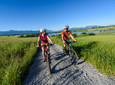
Beautiful gravel tour to the famous rococo church. The loop offers beautiful viewpoints and is ideal for exploring the Blue Land, the Pfaffenwinkel and the Ammergau Alps.
Good to know
Directions
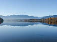
The round starts at the train station in Murnau. From there you can follow the signs “Staffelsee-Panoramarunde” in the direction of Uffing. Head north past Lake Staffelsee and head towards Bad Bayersoien. In Kirmesau you turn right towards Schönberg. Cross the Echelsbacher Bridge to Schwaigsee and continue via Morgenbach to Wildsteig. Via Schwarzenbach you finally reach the Wieskirche. The Königsstrasse takes you to the Ammergau Alps. Via Bad Kohlgrub and through the Murnauer Moos you finally get back to Murnau a. Staffelsee.
safety instructions
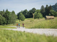
Please always be considerate of pedestrians and hikers. Make yourself noticed in good time, reduce speed and get off on narrow paths and push the bike. We appeal for respectful interaction between hikers and cyclists.
In an emergency, please contact the nearest rescue control center. Regardless of your location, you can reach them anywhere in Germany by calling 112.
The hiking and cycling paths we describe are primarily used for forest management; you use them at your own risk (Section 14 Para. 1 BForestG).
Facilities
To guarantee a smooth bike tour, we recommend the following equipment:
Bicycle helmet
Gloves
Short or long cycling shorts
Short or long jersey
rain jacket
Good shoes, possibly with a click
sunglasses
Hydration
Meals
First aid kit
GPS device + second set of batteries
Current map (scale 1:50)
Replacement hose, pump
Tools
camera
Money
Arrival & Parking
By train to Murnau main station.
By car: From Munich via the A95 and St2062 and from Garmisch-Partenkirchen via the B2.
Directly at the main train station.
Public transportation
Bus stop: Murnau train station
Bus routes in and through Murnau:
9601 Weilheim - Huglfing - Uffing - Murnau
9607 Murnau - Ohlstadt - Ettal and back (Note: only open on Saturdays on school days at the Ettal monastery school!)
9611 Kochel - Schlehdorf - Großweil - Ohlstadt - Murnau (Note: The Glentleiten open-air museum is only served from April to October!)
9620 Murnau - Riegsee - Aidling - Murnau
9621 Murnau - Seehausen - Grafenaschau
9631 Murnau - Obersöchering / Uffing - Eglfing
9641 Murnau - Seehausen - Uffing - Kirnberg Train stop: Murnau train station and Murnau Ort (Murnau - Oberammergau route) Murnau train station (Munich - Murnau - Garmisch-Partenkirchen route)
Guests in the “Blue Land” region and the “Ammergau Alps” can use a variety of bus lines and train lines from Murnau to Oberammergau and from Uffing to Garmisch-Partenkirchen free of charge with the electronic guest card or KönigsCard. Further information can be found at: https://www.dasblaueland.de/mobil
Selected Literature
Cycling map Ammergau Alps + Blue Land
Map
You can obtain maps from the tourist information centers and the municipal administrations in the Blue Land. You are welcome to order brochures using our brochure ordering tool at www.dasblaueland.de.
More information / links
author
Simon Bauer
Organization